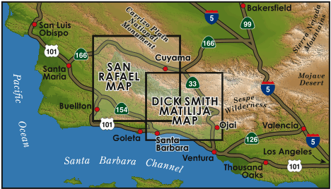
If you are an outdoor recreationalist who lives in Southern or Central California, or if you’ve ever wanted to explore the coastal mountains and canyons of Santa Barbara and Ventura Counties – then this site is for you.
Over the past 20 years I’ve been fortunate to spend a lot of time hiking, camping, biking, backpacking, riding and exploring the local mountains of SB and Ventura Counties. I also happen to be a cartographer. After enduring a particularly frustrating hike across the Hurricane Deck, where the mileage differed drastically between the existing maps, trail signs and actual mileages – one thing led to another and the next thing I knew I was making maps of the hiking and mountain trails of this area – and loving it!
In 2003, after 3 months in the backcountry and hundreds of hours on the computer, I released my first map of the San Rafael Wilderness. I had so much fun building that map, I had to do it again. In 2006 I dreamt up an idea to map the areas between the San Rafael and the Sespe Wildernesses and in 2008 the Dick Smith & Matilija Wilderness map was completed.
Since 2003, so much has changed throughout the southern Los Padres backcountry. Between volunteer trail maintenance projects, some wet seasons (remember those?), Forest Service efforts and most importantly FIRES, the trails and landscape have changed dramatically. I try my best to keep track of these changes, regularly update the maps and release new versions of each map every 3-5 years. Between regular monthly backpacking trips into the backcountry each year, religiously browsing the internet and talking with anyone and everyone I can about the forest, I truly feel these maps are the best, most accurate maps you can find of the southern Los Padres. Contrary to some of the other maps out there, my maps are all 100% field checked and created locally.
If you have plans of exploring any of the Santa Barbara or Ventura backcountry areas, I think you’ll find that these maps will enhance your experience along the trail and at the same time help you plan your trip from home.
Both maps are extremely detailed; featuring trail conditions, camp locations, trail mileages, points of interest, shaded mountain relief, GPS grid coordinates, and are printed on tear resistant waterproof paper. The maps are useful for all outdoor recreation; including hiking, equestrian use, motorcycling, mountain biking, dirt biking, OHV, backpacking, climbing, and those of us seeking a relaxing break from the grind.
For more information about each map click the map titles below. I’ve also provided a listing of place names that occur within each map. If you know a place you’d like to visit, search for that name within the site and it should point you towards the best map. If that fails, email me and I’ll be more than happy to help with whatever I can.
I hope you put the maps to good use and please if you have any questions or comments about the map, trails, trip routes or anything else map/backcountry related, feel free to drop me an email: BryanConant@yahoo.com
Thank you very much for your support and have fun,
Bryan


©2015 Bryan Conant


