

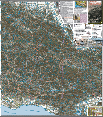
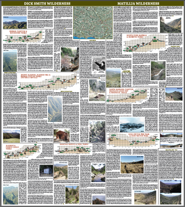
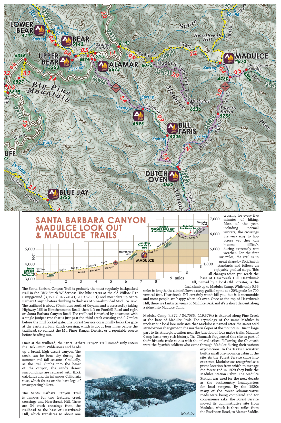
 The Dick Smith Wilderness and Matilija Wilderness are both within the southern Los Padres National Forest. They are located in the mountains roughly north of Santa Barbara, northwest of Ventura and south of the Cuyama Valley. Most of the trailheads are less than an hour from a nearby freeway, yet the high peaks, trails and deep canyons that span the wildernesses remain relatively quiet from human visitors. No matter what your backcountry passion (hiking, backpacking, peak bagging, horse riding, climbing, hunting/fishing or reading under a tree) there is a spot waiting for you to explore in either the Dick Smith or the Matilija. This newest edition (2013) of the Dick Smith & Matilija Wilderness Map is a complete update from the original print version (2008). New colors, updated trail information, new camp additions, completely reviewed mileages and….. (drum roll)….. a backside of the map! The backside has write-ups on each of the wilderness trails that include GPS coordinates of each camp, backcountry history, detailed information of each trail and a dash of local flavor. The backside also has a bunch of pictures, trail elevation profiles and a small satellite map locator. You can see some samples and pictures of the map below.
only $10.95 + shipping


Just as I’ve done for the past maps, my dogs Ben and Bailey led me as we hiked each of the wilderness trails to get the most up-to-date trail conditions, mileages and camp locations.

Due to the remoteness of the trailheads that access the Dick Smith Wilderness, it is far less visited than its neighboring wilderness areas. This solitude and isolation make up a key component of the Dick Smith’s personality. Whether you are swiming in the amazing pools that this area is famous for, or climbing 6500+ft Madulce Peak, you most likely will have the trails and camps to yourself.

The Matilija Wilderness is located less than an hours drive from Ventura and just a few minutes from Ojai. It’s a popular destination for dayhikers and in my opinion is one of the special gems of the Southern Los Padres. While its close proximity to civilization make it a great for day trips, the Matilija also offers great weekend backpacking options. Literally days and days worth of exploration options radiate from these trails. You just need to make the time and have the passion to venture further than a days worth of hiking.
The Matilija has never been mapped to the level of detail and scale of this map. Whether you are a seasoned veteran of the Matilija pools and falls, or a first timer looking for a quick escape from your daily routine, this map is worth checking out.

In addition to the Matilija and Dick Smith Wilderness areas, this map also covers many of the adjacent backcountry regions. The map spans from the SB frontcountry to the Cuyama foothills, and from the Ojai Highway 33 corridor to South Fork Station in the San Rafael Wilderness.
The map features OHV and motorcycle designated trails, and covers many of the famous local mountain bike trails (including Little Pine Mountain, Santa Ynez Mountains, and the SB and Ojai frontcountries).
If you can spare a few days or spend a few weeks, there are many backcountry loop and shuttle trip options available for the experienced or novice backpacker. This map serves as a great resource for planning all your packing options. Feel free to contact me should you have any questions about potential trips or trail conditions.
MAP FEATURES
• Printed on tear resistant waterproof paper
• Full color user friendly graphics
• Shaded relief with topographic contour lines
• Created with GPS and GIS technology
• Accurate trail mileages and camp locations
• Designates trail conditions and quality
• Zaca Fire permeter shown on map
• Map dimensions: 28” x 31.5” unfolded – 4” x 6.3” folded
Click images above for more detailed view of front and back portions of the map
The map is great for taking on the trail and folds up easily to fit in your pocket or the top pouch in your pack. Retail price is $10.95 + $2.00 shipping and handling for the folded map and will arrive in an envelope to your mailbox within a few days.
I invite you also to check out the San Rafael Wilderness Map. If you’d like to order more than 2 maps or are interested in wholesale please contact me directly at BryanConant@yahoo.com.
If you have any questions or comments regarding any of the trails, camps, or anything else pertaining to the map feel free to contact me at BryanConant@yahoo.com

Also check out the General Information page for additional information and map updates.
Thank you very much for your support and enjoy your time in the Southern Los Padres National Forest!

For more information on the Southern Los Padres National Forest check out www.HikeLosPadres.com or www.SantaBarbaraHikes.com.
©2013 Bryan Conant


One thought on “”